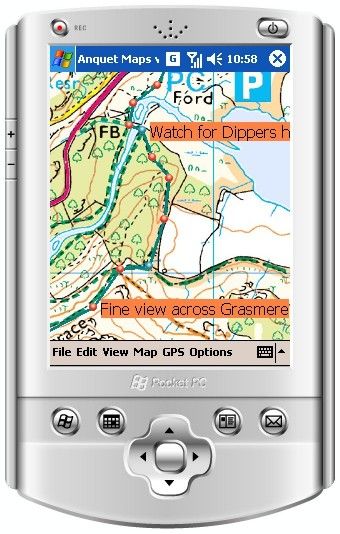
The key to a good romp through the countryside is planning. Planning your route can be almost as big a part of a country ramble as the walking itself. Anquet believe they have the software for the job; we pull on our walking boots to find out.
Our quick take
Overall, it doesn’t stack up well for Anquet Maps. The software is clunky and not the most logical to use. The concept of using a Pocket PC GPS for your route is not something we favour. A simple map, compass and route card or overlay will do the job, whilst ensuring you have at your finger tips all the information you might need, and tools that do not rely on batteries.
Anquet Maps might appeal to those who need to plan and share a lot of routes, for those who want to plan a walking route in the office and then meet friends at the first waypoint. However, experinced walkers will probably find is just as easy to look at the paper map, visualise the terrain and make their plans.

Anquet Maps - 2.5 / 5
| FOR | AGAINST |
|---|---|
|
|
Anquet Maps is essentially Ordnance Survey mapping on your PC and PDA or smartphone. Divided into a number of different maps, you can buy for the region that you want – so if you regularly walk in the Peak District, you can simply buy the maps for that area.
The software provides you with the tools to plan a walking route using the maps, you can add waypoints, all the time viewing the information that you might not otherwise grasp when looking at a map. You can switch to 3D mode and move through a virtual landscape, so you can really see what you might be walking at.
These tools also move over to your GPS-enabled Pocket PC, we used the Mio P350, reviewed here on Pocket-lint. Having the details on the Pocket PC means you can track your route as you go. Of course you can print the route from your PC as well, so you know exactly what you are doing, and include notes and so on as you like.
There are many features that make this a useful option for walkers. You can view split screen maps, so you can have different scale maps on the screen so you know where you really are. You can also link up with the Anquet website and search for routes by various criteria – making recreational walking a simple case of finding your location and what you want to do, and the distance. There doesn’t seem to be a route to meet many of the desired options, although we imagine this would change over time.
However, the software itself is not the most straightforward to use. We, despite experience with a wide range of applications, struggled to unleash all the features without having to search out instructions. The same applied with the Pocket PC version – we had trouble getting things to work.
The problems don’t end there. There is the matter of principle. This software offers a range of tools, which is fine, but it cannot replace the cornerstone of navigation – the map and compass. Whilst you could take a PDA GPS device on your walk, if you were doing anything other than a simple hour or so, then you’d be asking for trouble – battery life, for example, could leave you lost, as could a limited screen size – spread out an OS map, and you’ve got miles and miles to land to examine, rather than scrolling round a 2-inch screen.
You can exchange data with other GPS systems too - which is something of a plus point - for seeing what you have done, including many Magellan systems, and interestingly, the Garmin 205 and 305 units, which are sport-specific, so those training in the hills can now examine their routes via this software, rather than on Google Earth.
However, we can’t figure out who would use this. Yes, you can plan a route, but you can easily plan a route on a map – any why take a home-printed map with you when you can use a genuine OS map? Again, there is a safety consideration here – inclement weather might see you lost, and without the wider details of a full map, you could lack those sighting points further afield.
To buy the entire Peak District from their National Park series would cost you £80. There are many maps, and many options, which is a plus - you can get what you want. We had map 145, Guildford and Farnham, which would cost you £24.95 electronically - the paper version would cost you £7.49.
To recap
Could be useful
