A satellite navigation system is only as good as the roads it takes you on - or so we’ve been told. Determined to put this premise through rigorous testing, we took the Navman iCN510 on an excursion through Europe, just to see where it took us.
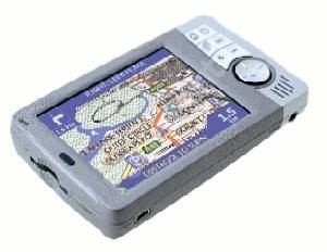
Let’s start with the display. The iCN510 performs well with a clear display that even in bright sunlight has sufficient contrast to allow you to see where you’re going. The touch screen is good and navigation around a variety of options is simple. Settings can be customized easily, allowing you to tweak the system to your own tastes.
During navigation (on the roads, not the menu!) it offers you a variety of views - including 3D, but, whilst looking impressive, quickly became tiresome and we opted for a more map-like display - with the map adjusting itself around the position of your car, allowing you to quickly spot that right angle bend ahead - a real bonus when driving unknown roads. The canned voice (available in both male and female versions) provides clear instructions and helped get us out of a number of fixes, although on long journeys it can start to grate!
When in England, with half an idea of where we were going, we tried to confuse the device. It didn’t work. Within seconds it had recalculated the route and set us back on track. It only asked us to perform a U-turn when there really wasn’t an alternative route to our destination. This, however, did present its own problems. Living in rural Wiltshire, we found ourselves being sent down barely drivable roads, although we put that down more to the highways agency than the satellite navigation.
On to the European epic. Setting off with minimal time to spare the system gave us a very clear indication of how fine we were about to cut it to reach the Channel Tunnel - we made it with 6 minutes to spare, having had to negotiate around the log jam created by militant French lorry drivers blocking the ferry ports.
The system didn’t automatically assume that we were travelling via the Channel Tunnel and instead opted to steer us towards the ferry terminals. On this point comes our first piece of advice - you need to use the sat nav with a bit of common sense. If the road signs point you towards the tunnel and the sat nav disagrees, always go with the road signs…
When on the continent, basemaps are provided as standard with the unit, giving you details of all the major routes. They proved surprisingly useful, especially on the mammoth 14-hour drive we embarked upon. You could say it really cut the mustard through Dijon…
The 510 proved the only thing that preserved tempers within the car on the trip (to Chamonix). Its confident directions left us in no doubt on the route to take, eliminating arguments over inadequate map-reading, although it can be depressing when it asks you to remain on the same road for 200 miles, telling you that you’ve only got another 11 hours of driving remaining!
The European maps come in at an additional £150, but if you’re going to be doing a lot of driving on the continent they’re probably worth it. Incredibly detailed, they proved invaluable when attempting to locate an inexplicably hidden coach station when picking up another member of our party in Chamonix.
One of the few gripes we had about the system was that the memory was not really sufficient for more than the essentials, meaning that serious travellers might either want to take a laptop along with them, or upgrade to one of the 510’s big brothers in the 600 range. With only a 128MB memory card as standard we only managed to fit the south of England, the European base maps and eastern France road maps on. You could of course increase the storage capacity of your card - but with the system costing £500 and the European road maps another £150, it seems criminal to have to spend more on additional storage.
It would be great to see Navman combining this excellent system with something like Road Angel (to notify you of any pesky traffic cameras etc) and a link to traffic congestion information - quickly routing you round the delay - now that’s really something we’d pay for.
Our quick take
It’s brilliant for those long trips, gives you the reassurance that you really are going the right way - with a 14-hour drive the last thing you want to do is to be diverted for even a few minutes. The Navman made sure that never happened.
Would you really use it? Yes - it’s great. However, we’re not sure we could justify the expense. On the other hand, it will save enormous amounts of stress when on a long drive where an unnecessary diversion can mean additional time being added to an already long journey.
Overall this is an excellent product - well designed, well executed and a lifesaver when venturing into unknown territory. Setting aside the minor gripes, we think it’s certainly worth consideration.

Navman iCN510 - 4.0 / 5
| FOR | AGAINST |
|---|---|
|
|
To recap
A portable in-car navigation system with a lot going for it