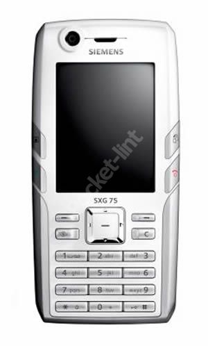
The Siemens GXS75 (due later this year) is a mobile phone and GPS unit combined in one handset. Pocket-lint flew to Germany to take a first look at the phone that promises the world in your pocket.
Our quick take
The idea of having a map of Europe in your pocket that doubles up as your phone really appeals to us here at pocket-lint. What doesn't appeal though is that unlike current GPS solutions you'll have to pay a monthly subscription for the fact. With an MMC slot it would be easy to provide a map of the UK or parts of Europe on a single memory card and be done with it. It's a shame Siemens isn't planning on offering this as an option.
Grumbles aside the phone, although rather bulky, does offer all the tools any business traveller would need and like its SX65 Blackberry device offers a good choice for the man or woman constantly on the move.
The GXS75 should be available by the end of the year.

Siemens GXS75 - First Look
| FOR | AGAINST |
|---|---|
|
|
While neither the concept of a handheld GPS or Mobile phone are new concepts on their own, the two together in one unit is, yes we've seen the GPS coupled with the PDA, but as yet (to our knowledge) no-one's bolted on a mobile phone at the same time. The idea is a simple one; whenever you've got your mobile phone with you, you'll also have a complete road map of Europe in your pocket as well.
The pure white phone is simple in its design and following other models in the 75 range, in our minds rather boxy and plain. The screen is large (obviously to allow for the map detail to be seen clearly) and the keyboard is unadventurous. Aside from the usual array of digital camera, Bluetooth support and tri-band connectivity the phone also has a MMC slot although rather annoyingly you will not be allowed to use this in conjunction with the GPS element of the phone. The software is server-based. In other words, you request the directions you need via Siemens server and it then downloads that information to your phone. To save download time the software simply downloads a corridor around your route.
In talks with the company it appears Siemens is still unsure how it is going to charge for this service. One possibility the company is toying with is that you would pay a set fee (say UK£10 a month) and the get access to the entire map of Europe. The other is that you would pay per direction request.
To get the set of directions, a start and finish destination is entered into the software and the map data is gathered from the database in the sky. It's an interesting approach and one that Siemens is obviously hoping will turn into a healthy revenue stream for them, but we have to question what happens when you want a set of directions and you haven't got a good mobile phone signal, how will you get the maps then?
The software itself looks easy to use. You can select Points of Interest as well as having the software allow for traffic jams all dynamically (again a subscription cost) so it changes your suggested route to avoid heavy jams or road closures. Like other GPS software applications you can also set preferences for the type of roads you prefer, ie motorways or toll roads.
The map presentation was clear and you can even have the phone speak the directions to you if you don't want to worry about taking your eyes off whatever else you are doing.
To recap
This combines the best of both worlds and should save you from having to ask for directions ever again.
